

What if the Serengeti migration routes on a map are better understood as a moving pattern than a single line? When planning a safari, it’s natural to look for a precise route and date. But the great herds respond to rainfall, fresh grass and water, so their location can shift from year to year. The broad circuit is dependable; the exact timing and position are not.
Seasonal summaries can therefore seem inconsistent. Read a route map as a guide to likely movement, not a promise of where herds will be. This article follows the annual journey, from calving in the southern plains through the western and northern stages, and explains what shapes each part. You’ll also find practical ways to assess migration maps and choose a safari region while allowing for nature’s timing. In the field, experienced local trackers help guests interpret changing wildlife locations and add context to each day on safari.
Key Takeaways
- Understand the Serengeti migration routes as a connected annual circuit across a wider ecosystem, not a single fixed track.
- See how seasonal rainfall, grazing and water influence where herds move.
- Follow the broad journey from the southern plains west and north, then back south, while keeping seasonal timing flexible.
- Assess migration maps by checking their date, scale and geographic coverage before using them to plan a safari.
- Learn how local trackers help guests respond to changing wildlife locations, including on a west Serengeti migration safari.
What Are the Serengeti Migration Routes? Understand the Annual Circuit
The Serengeti migration is the recurring movement of grazing animals across the Serengeti ecosystem in search of fresh pasture and water. Wildebeest are its best-known participants. Their large herds move through changing landscapes as seasonal conditions shift. This is a broad ecological pattern, not a procession along one marked trail.
The Serengeti migration routes describe this seasonal movement between feeding areas. They help explain how herds may move between the southern plains, western parts of the ecosystem and northern ranges, but they cannot show where every animal will be on a particular day. Rainfall and grass growth influence where grazers gather, and conditions vary across the region. The Serengeti National Park and the Great Migration overview offers further context on the ecosystem and the animals that move through it.
A migration route is the herd’s broad seasonal pattern, not a pin on the map marking its location today.
Which animals take part in the Serengeti migration?
Wildebeest are the migration’s most familiar travelers, but they share the wider ecosystem with other grazers. Zebra and gazelles also move in response to food and water. They don’t necessarily travel in the same numbers, at the same time, or along the same paths as wildebeest. The result is a shifting mosaic of wildlife, not one uniform herd.
Lions, hyenas, cheetahs and other predators are an essential part of this living landscape, but they aren’t migration participants in the same sense as the grazing herds. Their presence is connected to the movement of prey and the rhythms of the ecosystem. For visitors, the distinction matters: migration describes the grazers’ seasonal movement, while predator sightings may unfold around it in less predictable ways.
Why is it called a migration circuit?
“Circuit” describes how seasonal movement links feeding grounds across the wider ecosystem and eventually brings many wildebeest back toward southern grazing areas as conditions change. It’s a useful way to picture the year as a connected cycle rather than a one-way journey with a permanent destination. In the southern plains, seasonal grazing and calving are associated with the period from December to March, though exact wildlife locations vary.
The word doesn’t mean every animal completes the same uninterrupted loop. Herds can divide, spread across broad areas or change direction as rain and grazing conditions shift. Zebra and gazelles may follow related but distinct patterns. Think of the circuit as a landscape-scale guide to recurring movement. It shows how feeding areas connect over time, not a fixed itinerary shared by every animal.
Why Rainfall and Grazing Shape the Serengeti Migration Route
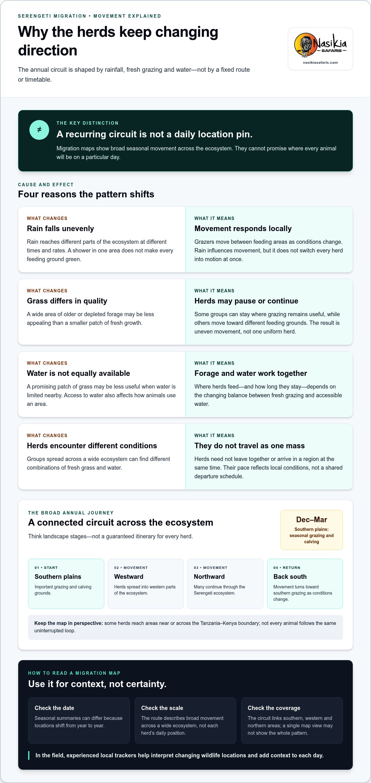
Rainfall helps determine where grazing becomes attractive, but it doesn’t move the herds like a switch. As rain reaches different parts of the ecosystem, grasses respond in different places and at different rates. Wildebeest and other grazers can then move toward areas with fresh forage, leaving behind grass that has been heavily grazed or has begun to dry.
As rain reshapes the supply of fresh grazing, the migration’s location shifts with it.
How do rainfall and fresh grass influence movement?
Rainfall patterns affect where suitable grazing grows, and the timing and distribution of rain can vary across the ecosystem. A shower in one area doesn’t mean every feeding ground is green or that all the herds will turn toward it at once. Animals respond to conditions on the ground, moving between seasonal feeding areas as pasture changes.
Grass quality matters as much as its presence. A broad expanse of older or depleted forage may be less appealing than a smaller area of fresh growth. This helps explain why movement can seem uneven: some groups may pause where grazing remains useful, while others continue toward different feeding grounds.
Why do herds move at different speeds?
Rain doesn’t fall evenly across the landscape, and grazing conditions can differ from one area to another. Herds spread across this wide ecosystem may encounter different combinations of fresh grass and water. They need not travel as one mass or arrive in a region together. Their movement reflects local conditions, not a shared departure time.
Water availability also shapes where grazers feed and how long they stay. A promising patch of grass may be less useful if water is limited nearby, while accessible water can influence how animals use an area. The balance between forage and water changes over space and time, making the migration a shifting pattern rather than a rigid timetable.
This is why a seasonal route summary can be useful while still differing from what a traveller sees on a particular day. It describes a recurring relationship between rain, grazing and movement, not a guaranteed schedule. The Serengeti migration routes are best understood at two levels: the annual cycle across the ecosystem and the changing positions of individual groups within it.
For safari planning, use seasonal patterns as context and allow for wildlife to respond to conditions as they unfold. Experienced local trackers help guests interpret changing animal locations in the field. A guided west Serengeti migration safari is one way to experience a region within this wider, rainfall-influenced movement.
Follow the Serengeti Migration Route from Southern Plains to the North
The annual route is easiest to picture as connected landscape stages, not a calendar of guaranteed herd locations. Many wildebeest use the southern plains as important grazing and calving grounds. Herds then spread westward and move north through the Serengeti ecosystem. Later, some reach areas near or across the Tanzania-Kenya boundary, before movement back toward southern grazing grounds completes the broad circuit. The pattern varies, and not every group follows the same path or timing.
| Route stage | Broad landscape | General seasonal context |
|---|---|---|
| Southern plains | Open grasslands and seasonal grazing areas in the south | Part of the annual grazing and calving cycle; Nasikia’s southern calving-season safaris operate from December to March |
| Westward movement | Western Serengeti and its broader corridor | A broad stage in the movement away from southern feeding areas |
| Northward movement | Northern Serengeti, extending toward the Tanzania-Kenya boundary | Herds may move through northern areas, with some crossing into the Maasai Mara |
| Return south | Route back toward southern grazing areas | As conditions change, many herds turn toward the southern part of the ecosystem again |
What happens in the southern Serengeti and calving areas?
The southern plains are an important part of the annual cycle, with grazing areas associated with calving. Nasikia’s southern calving-season safaris run from December to March, offering a way to experience this stage. Treat that period as a broad seasonal guide, not a promise that herds will occupy one precise location throughout the entire window.
How do the western and northern stages connect?
The western corridor is a broad stage in the northward movement, linking southern feeding grounds with areas farther north. Northern Serengeti landscapes are part of the wider route before many herds turn south again. Some groups may continue across the border into Kenya’s Maasai Mara, but this movement shouldn’t be assumed for every herd or every season.
These stages make the Serengeti migration routes easier to follow without turning them into fixed predictions. A herd’s position can differ from the broad pattern shown for a season, and groups may be spread across several areas at once. Nasikia’s west Serengeti migration safari focuses on one distinct region of the circuit, while a southern calving-season safari offers a different perspective. To compare them, start with the region and stage that interest you, then keep the route’s natural variability in mind.
How to Read Serengeti Migration Route Maps Without Overpromising
A migration map is most useful as a guide to broad seasonal movement, not as a live tracker. Before using one to shape safari plans, check three details: when it was prepared, how much of the ecosystem it covers, and what its labels describe. A map showing a typical month may indicate a likely region. One focused on a particular park or corridor may not show movement beyond its boundaries.
What can a migration map tell you?
Maps can show how seasonal areas connect, from southern grazing grounds toward western and northern parts of the ecosystem. A month-by-month map can suggest where herds are often found during a broad period, helping you compare safari regions. It can’t show every group’s position or account for each local change in conditions.
Read the map’s date and scope before interpreting its seasonal labels. Check whether it shows an average pattern, a particular year or a current observation, and whether it includes an update date or an explanation of its sources. Scale matters too: a broad regional map gives a different level of detail from one focused on a specific area. These checks help you use the map as context rather than treating its shaded areas or arrows as precise predictions.
Rainfall can shift both the timing and position a migration map suggests. If conditions change across the ecosystem, herds may appear earlier, later or in a different nearby area than a typical seasonal summary implies. Compare the map’s broad pattern with current information from appropriately sourced updates where available, and note the date of each update. If sources differ, they may describe different periods, areas or levels of detail rather than disagreeing about one fixed route.
What can a migration map not guarantee?
No route map can guarantee the exact location of a herd on a particular day or that animals will be visible from a specific viewpoint. Maps also can’t promise a river crossing. Crossings depend on animal movement and local conditions, so even a map that marks a well-known crossing area can’t make the event certain during a visit.
For planning, use the map to choose a broad region and seasonal window, then keep expectations flexible. Experienced local trackers help guests interpret changing wildlife locations in the field, adding timely context to what a static map can show. Nasikia’s guided migration safaris offer ways to experience different parts of the circuit, including the west Serengeti and the southern calving season. Explore Nasikia’s guided migration safaris to compare the regions and consider which best suits your interests.
Experience the Serengeti Migration Route with a Guided Safari
Following the migration is not simply a matter of choosing a month and driving to a marked point on a map. The herds move in response to changing conditions, and their location varies across the ecosystem. On a guided safari, experienced local trackers help guests interpret where wildlife is moving and focus observations on what is happening in the landscape, rather than treating a seasonal route as a fixed itinerary.
How does guided tracking support a migration safari?
Experienced local trackers guide guests across prime Serengeti viewing regions and help make sense of changing wildlife locations. Their knowledge helps direct attention as conditions and animal movements evolve, while the surrounding landscape remains part of the experience. A herd may be visible in one area and elsewhere another day, so guiding supports responsive decision-making, not control over wildlife or a guarantee of sightings.
Which migration safari experience fits your interests?
Nasikia’s 8-Day Midrange West Serengeti Migration Safari offers a way to experience the western stage of the wider migration circuit. It may suit travellers drawn to the west Serengeti and interested in how this region fits into the annual movement. The safari name identifies its broad focus, but it isn’t a promise that herds will occupy a particular place on a particular day.
Nasikia’s southern calving-season safaris, offered from December to March, provide a distinct seasonal perspective in the south. The west Serengeti safari and southern calving-season safaris focus on different parts of the migration. Start by considering which region and stage interest you most, while leaving room for wildlife to move according to its own rhythms.
A thoughtful guided journey is about more than reaching a location on a route map. It also includes the changing scenery, the details a tracker helps you notice and the patience to observe wildlife without expecting nature to follow a schedule. If you’re considering a safari, explore guided Serengeti migration safaris and compare the experiences that reflect your interests, remembering that sightings can never be guaranteed.
Let the Living Landscape Shape Your Safari
Planning a migration journey can begin with a simple question: which part of the Serengeti would you most like to experience? Instead of building expectations around one predicted herd position, consider the landscape, season and style of safari that appeal to you. Then leave room for the unexpected moments that make a wildlife journey memorable.
As a licensed Tanzanian tour operator, Nasikia Safaris offers guided wildlife safaris shaped around distinct parts of the migration, including the west and the southern calving season. Experienced local trackers help guests respond to changing wildlife locations across prime viewing regions, while recognizing that nature follows no guaranteed schedule. The Serengeti migration routes are an invitation to explore a remarkable ecosystem with curiosity and flexibility.
Whether you’re drawn to the western stage or the southern plains, choose a journey that fits your interests. Explore Nasikia’s guided Serengeti migration safaris and start planning an experience shaped by the season, the landscape and the wildlife you encounter along the way.
Frequently Asked Questions
How many wildebeest take part in the Serengeti migration?
The migration is widely described as involving more than a million wildebeest, alongside other grazing animals. Treat that as a broad estimate rather than a permanent headcount: figures can differ between sources and years, and counting animals spread across a large ecosystem is challenging. For research or travel planning, look for a current estimate from a conservation or research source and check when it was published.
How far do wildebeest travel along the migration route?
There isn’t one distance that neatly describes every wildebeest’s journey. Published figures depend on how researchers or writers define the route and which herds they follow; animals don’t all trace an identical line. For practical purposes, picture a journey across a broad ecosystem spanning seasonal feeding areas, rather than a measured path shared by every animal. Treat any specific distance as an estimate and check its source and method.
How long does the Great Migration take?
The Great Migration is a recurring annual cycle, not a single journey with one departure date and finish line. Herds move through different areas as conditions change, and individual groups may take different paths or spend varying lengths of time in a region. For trip planning, choose the season and broad area that interest you, then allow flexibility rather than expecting every herd to complete the same route on a set schedule.
Do all wildebeest travel together in one herd?
No. Wildebeest can spread across a wide area and move in separate groups, so a migration map may represent a region of activity rather than a single dense gathering. Animals shown within the same broad zone might be dispersed across different grazing areas. This distinction is useful when interpreting maps or safari updates: a regional herd indication doesn’t mean every wildebeest is visible from one location at the same time.
Do zebras migrate with wildebeest?
Yes, zebras move through many of the same broad Serengeti-Mara migration areas, but they don’t necessarily travel as one mixed herd with wildebeest. Different grazing habits can influence where each species feeds and how it uses the landscape. On safari, you may encounter zebra and wildebeest in the same general region without seeing them move together. Their presence contributes to the wider seasonal movement, not a synchronized journey.
Are river crossings guaranteed on a Serengeti migration safari?
No, river crossings can’t be guaranteed. Even if herds are nearby, they may not approach or cross a river during your visit; animal movement and conditions at the river shape what happens. A guided safari can help guests respond to changing wildlife activity, but it can’t set the timing of a crossing. Plan around the broader wildlife experience so the journey remains rewarding even if a crossing doesn’t occur.
Why can the migration route look different on different maps?
Maps can differ because they show different dates, geographic areas, levels of detail or kinds of information. One may illustrate a typical seasonal pattern, while another reflects a particular year or focuses on a smaller area. Before comparing them, check the date, coverage and any explanation of how the map was made or updated. Use Serengeti migration routes as planning context, not as live locations.

